And from that day, o'er hill and glade,
through those old woods a path was made.
Here are the most recent news and ideas from Calf Trail.
For the most convenient access, subscribe to our feed in your favorite newsreader!
2010 October 23
This week Apple announced a new version of iPhoto, and the Mac App Store, and this week I am officially calling it quits here.
Geotagalog 2.0 seems to have broken on iPhoto '11 (at least partially) before I even found the time to get it out of beta.
I suspect it's something small related to the database format, but to be frank I'm not going to buy the iLife upgrade just to look into that.
I've stopped throwing time away to iPhoto so
I can help build something better instead.
Furthermore, with the announcement of the Mac App Store, Apple has broken any lingering hope I had for one day succeeding at indie Mac development.
Being treated as a responsible adult, innovating without restriction, connecting directly with customers, and being able to fix my mistakes quickly —
the things I cherished most about my job at Calf Trail — are being gradually replaced by a "submission" process.
I've put off really, for surely, officially quitting (even in my previous "there's been a change of plans" post) because I didn't want to let down
the dedicated users (which I guess includes myself) who found, chose, and stuck with the software we were building. Rather than pretend that's not already
happened by my neglect, it's time to admit that my passions and priorities have changed, and it's time to end my commitment here as well as I can:
I've shared basically all of Calf Trail's interesting source code, including the complete source for Geotagalog and
Sesamouse (and even Mercatalog)
as repositories on GitHub. So now everyone has access to the stuff Calf Trail's Mac softwares were made of,
except for the "me" piece, and I'm willing to give tips and pointers around specific parts of the code. I know that not all our former customers are programmers
(that was the point of our software) but I do know that many of you are rather creative, intrepid folks who might be able to figure out some way
to get these pieces picked up and running again.
It's been a long trek, and I'm so so so grateful to my family (especially Hannah, for her patience and her generous icon drawing)
and friends (especially Hjon, for his patience and his huge contributions as co-founder of the company) and to everyone who ever emailed us or commented here.
Your encouragement made Calf Trail one of the most worthwhile life experiences I've had so far, no matter whether the business itself succeeded or failed.
God bless, and keep in touch!
2010 July 5
Hello everyone. There are some things that I've been needing to share with you, but aren't easy to say.
-
I have been hired full-time at an awesome web development company
To work fulltime designing desktop software for end-users has been a lifelong dream of mine. After two years of trying, I finally had to admit that this dream wasn't coming true.
I'm bad at marketing to begin with, and it has become harder and harder to share news about my work now that most Mac publications are focused on Apple's closed platforms instead.
When &yet offered me a place amongst their hard-working, fun-loving, all around world-class team I
gratefully accepted and haven't looked back.
-
I plan to make Geotagalog and Photon Star free soon
Since accepting my new mission in May I haven't been able to dedicate much time to Calf Trail's software. I do not intend to abandon the products or their customers,
but I think making them free is the right thing based on the situation.
I do appreciate every single customer and am grateful for your patronage. If you purchased a license recently, I'd be happy to issue a refund.
-
I have given up on iPhoto
I've finally concluded that the time I spent (as a user and as a developer) dealing with iPhoto's disappointments would have been better spent on a better solution.
With "Calf Trail time" now even more precious, I hope to operate the company as more of a research and development laboratory working towards better photo managament ideas.
I've started on this already and hope to share more as progress permits. I want the future to be open-ended, and I want the future to be de-centralized.
Any questions?
2010 April 29
It's finally here.
...almost.
Geotagalog 2.0 is now in public beta. Please report any issues or confusion you encounter.
So what is Geotagalog 2.0? What's new?
Executive summary
- Now properly handles photos that are already imported into iPhoto.
- Can assign iPhoto Places without modifying original files.
- Can optionally geotag photos without any iPhoto import.
- New "geotag helper" does the slow work in the background.
- Now requires Snow Leopard (10.6)
Visual summary

As I've mentioned before, I'm really excited about these new features.
Geotagalog 2.0 doesn't look much different than 1.5, but these behind-the-scenes changes make Geotagalog much more powerful.
And flexible. Without adding much complexity. (It was hard.)
Quick start
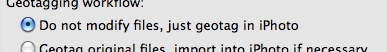
If you just want your pictures to show up in iPhoto's Places, just use Geotagalog like normal.
When you want to tag photos that are already in iPhoto, just load the tracklog as usual.
Then simply drag photos from iPhoto and drop them onto Geotagalog. (Or select them via the Media section of the "Choose files and folders..." dialog.)
Geotagalog will automatically detect that they are part of your iPhoto library and not try to import them a second time. Of course, if the photos are
still on your camera or memory card, they'll automatically be downloaded and imported into iPhoto just like in Geotagalog 1.x.

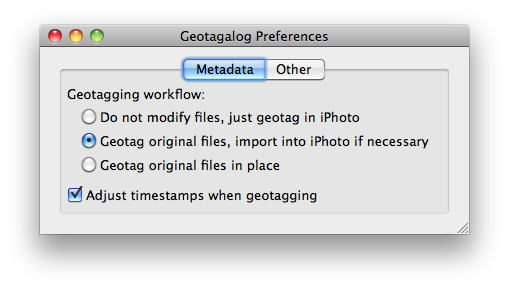
If you really need to write the geotags to the original files, you'll need to go into Geotagalog 2.0's preferences and choose the
"Geotag original files, import into iPhoto if necessary" workflow option. This is similar to the first option in that it imports into iPhoto
only when the photos aren't already in your library. The key difference is that if your photos are already in iPhoto, they will be added to
an album called "Rescan for Geotagalog" and you will need to select them all, right click and choose "Rescan for Location" before they show up in Places.

And finally, if you don't use iPhoto at all and just want to easily and visually add geotags to your JPEG and RAW photo files, you'll need to set
the workflow preference to "Geotag original files in place". With this option, the files you drag in or select via "Choose files and folders..."
are simply geotagged in place on disk.
Upgrade
If you bought Geotagalog 1.x after 2009 October 22, the upgrade was included.
If you bought Geotagalog before then, the upgrade to 2.0 costs $15 (40% discount).
If you don't have a Geotagalog license, the full price remains at $25 for now.
Use our handy license upgrade page to check your status and generate your free or discounted upgrade coupon.
Download

Download Geotagalog 2.0 beta
Requires Mac OS X Snow Leopard (10.6)
I plan to make a video screencast and update the tutorial and product page and help file with more details during the beta, but I didn't want that
to delay this release. If you have any questions whatsoever, leave a note in the comments or send me an email.
Update/download
Geotagalog is now a free app, although it is still in beta until I can update the help files and a few other loose ends.
See this post for details.
Download Geotagalog 2.0 beta 2
Requires Mac OS X Snow Leopard (10.6)
Copyright © 2008–2010 Calf Trail Software, LLC. All rights reserved.